- Description
- Specifications
- Shipping
Unparalleled Coastal Chart Coverage
-
Provides industry-leading coverage, clarity, and detail with updated coastal charts featuring integrated Garmin and Navionics data
-
Auto Guidance¹ technology calculates a route using your desired depth and overhead clearance, providing a suggested safe path
-
Depth Range Shading for up to 10 ranges allows quick viewing of target depths
-
Up to 1’ contours deliver precise bottom structure details for improved fishing and navigation in swamps, canals, and marinas
-
NOAA raster cartography available as a free downloadable feature via the ActiveCaptain app
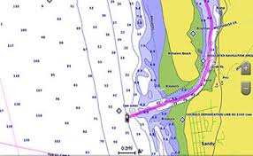
BlueChart g3 coastal charts combine Garmin and Navionics data for unmatched chart detail and clarity. Auto Guidance¹ uses your depth and clearance preferences to calculate a suggested safe route, directly overlaid on your charts. With NOAA raster cartography, you can also access paper chartlike views of surveyed areas with longitude and latitude details. Worldwide coverage is offered by region as accessory cards or downloads (sold separately).
Auto Guidance Technology
The Auto Guidance feature¹ calculates a suggested route based on your chosen depth and overhead clearance.
Special Offer
Garmin rebate available — check Garmin promotions for details.